The Journey Is The Destination
Key Largo to Key West Via Florida’s Only All-American Road
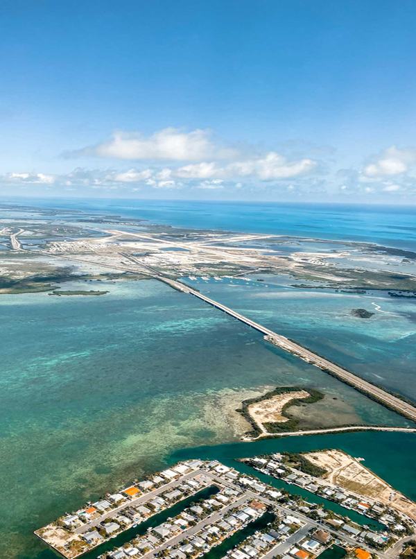
Key West may be one of America’s most notorious end-of-the-road party towns, but in this case, getting there can be as much fun as the destination itself. Spanning 110 Miles over 43 alluring islands, the Florida Keys Scenic Highway is Florida’s only “All-American Road” — a prestigious designation it shares with only 29 other American roadways. And with good reason.
Flanked by the gentle turquoise waters of the Gulf of Mexico on one side and the majestic Atlantic Ocean on the other, this historic, archeologically significant road, with its endless vistas, unique flora and fauna and world renowned recreational areas, is a destination unto itself. Sometimes called “the Highway that Goes to Sea” — follows a trail originally blazed in 1912 when Henry Flagler extended his Florida East Coast Railroad from Miami to Key West.
Take your time because this road has been heralded as one of the most spectaculars roads in the world. Seascapes as colorful as any artist’s palette, colors of shimmering sea from turquoise to blue to deep green, landscapes of rustling pine, swaying palms, silver buttonwood and water-rooted mangrove, all vying for life under a horizon-to-horizon blue sky dotted with fleecy white clouds. There are plenty of out-of-the-way stops along the drive where you can see mangrove swamps, crocodiles, pelicans and rare wild orchids. Don’t be surprised if you spot dolphins splashing in the waves, manatees floating in the shallows and endangered birds gliding overhead.
Florida Keys Scenic Highway
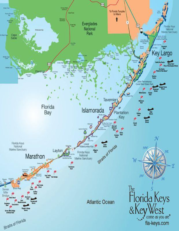
 The Florida Keys Scenic Highway runs from Mile Marker 110, north of the spectacular Jewfish Creek Bridge, to Mile Marker 0 in Old Town Key West. The scenic highway corridor also extends five miles into our crystal clear waters on each side of the highway. The Florida Keys Scenic Highway truly encompasses all of the Florida Keys, its natural wonders, and its communities. The Keys highway is the only All-American Road in Florida. It’s the highest recognition possible under the National Scenic Byways program established by the U.S. Congress in 1991. Only 30 other roadways in the nation have earned the prestigious title. Under the National Scenic Byways program, roads can be recognized as National Scenic Byways or All-American Roads based on their archeological, cultural, historic, natural, recreational and scenic qualities.
To earn All-American Road status, a thoroughfare must possess characteristics of national significance and features that don’t exist elsewhere, making it a visitor destination in itself. The highway began first as a railway meant to make business easier for its founding developer. Henry Morrison Flagler’s legacy railroad began as a means to connect his string of Florida hotels along the state’s sparsely developed east coast. A bold plan that would take an incredible amount of years and funds to finish, and was not fully completed until January of 1912, when Flagler was 82 years old. After the Great Labor Day Hurricane of 1935, the badly damaged railway was replaced with a two lane concrete road which opened up entirely new opportunities for motorists and business in Florida’s southernmost islands. Over the decades, ongoing improvements and technological advancements have continued to make the famous highway a unique and rewarding highlight for things to do in Florida Keys vacations. In 1982, thirty-seven of the original bridges including the Seven Mile Bridge were replaced with wider spans. Many of the old bridges can still be seen running alongside the newer ones. Designation as an All American Road in 2009 cemented the highway’s status as a modern national treasure. scenichighwayflkeys.com Downloadable PDF Map
John Pennekamp Coral Reef State Park
 The “Grand Canyon” Of The Keys Established in 1963, John Pennekamp Coral Reef State Park was the first undersea park in the United States. Named for an environmentally conscious Miami newspaper editor, this is the “Grand Canyon” of the Keys, a place of clear-water wonders, where fish swim and lobsters crawl and colorful living organisms make up the reef. Combined with the adjacent Florida Keys National Marine Sanctuary, the park covers approximately 178 nautical square miles of coral reefs, seagrass beds and mangrove swamps. If you love lots of outdoor activities, below and above the water, this is the place for you. Before getting started, stop by the park’s Visitor Center which is loaded with good information and will give you some background on the park’s marine and wildlife resources. There is also a 30,000 gallon saltwater aquarium, here, as well as several exhibits and a theater showing nature videos.
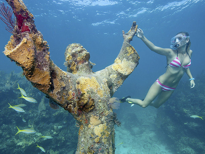
Diving & Snorkeling at John Pennekamp Coral Reef State Park The coral reef at John Pennekamp Coral Reef State Park is part of the only living coral reef in the continental United States and is among the most beautiful and diverse of all living communities. The park extends 3 miles into the Atlantic Ocean and is approximately 25 miles in length. This is a protected area and divers are not allowed to touch or step on the reef because it is not only fragile, but also alive. Three miles offshore lies the famous Dry Rocks Reef, so named because the landward section sometimes pokes out of the water at low tide. Here, venus sea fans and reef squid share the reef with mangrove snapper, blue tang and Bermuda chub. Dry Rocks Reef is also home to the famous “Christ of the Abyss” — an 8 1/2 foot, two ton bronze statue of Jesus Christ that resides 25 feet down. Water Activities At John Pennekamp If snorkeling and diving aren’t your thing, you can always view the reef from one of the glass-bottom boats. There are also canoe, kayak and paddle board rentals so you can explore the 50 miles of calm waters and mangrove forests.
Exploring John Pennekamp Park There’s lots to explore from land, as well. The park contains a wide variety of tropical vegetation, shore birds and marine life. Nature trails and wheel chairaccessible boardwalks make for an easy go around the tropical hammocks and mangrove swamps. There are also designated areas with barbecue grills for picnicking. John Pennekamp Park Beaches If you just want to relax, check out the park’s two beautiful beaches. Cannon Beach is close to the main concession area. It has a cannon on the beach and offers the best snorkeling. In fact, there is an authentic replica of a Spanish ship wreck just 100 feet off the beach The other beach is called Far Beach which is shadier and good for swimming and relaxing. Camping At John Pennekamp The park also has a campground with 47 sites. All of the sites are back-in with full hookups and we were in campsite 4. The site is gravel with a picnic table and trees between sites for privacy. For more info go to pennekamppark.com
Indian Key
 A Storied Past In the early 1820s, young John Jacob Housman set sail for Key West from Staten Island, New York. Houseman was personally indoctrinated into the Keys’ wrecking industry when he ran aground before reaching shore. At the time, Key West was the epicenter of the wreaking salvage business in the Florida Keys and Houseman made a point of learning the intricacies of the business. It wasn’t long before he became one of the most infamous, unscrupulous wreckers of the time. With stiff competition in Key West and his unsavory reputation, Houseman decided to move further north and set up a station on the tiny island of Indian Key.
In 1830 Houseman purchased a one story building with two rooms and a kitchen for $30. Less than a year later, he purchased a two-story house, a store, a 9-pin bowling alley, billiard room, outhouse and kitchen from Thomas and Ann Gibson for $5,000.00 Housman had a vision for Indian Key and began to develop it into his own mini-empire. By 1835, Houseman had purchased all rights and titles to Indian Key including all buildings and improvements for $5,000. Within ten years, he had laid off streets, expanded wharfs and had cisterns cut into bedrock. Although it was just over 10 acres, Indian Key became a thriving port and in 1836, Houseman persuaded the Legislative Council to establish Indian Key as the county seat for Dade County. Around that same time, the tensions of the Second Seminole War were beginning to be felt in the Keys.
Housman took almost immediate action to protect his investment. He established Company B, 10th Regiment Florida Militia with himself as commander and a cadre of 38 men including 6 slaves. In 1838, despite being warned of the growing Indian unrest, Dr. Henry Perrine, the former US Consul in Mexico, moved to Indian Key with his family to pursue his interest in exotic agricultural. Perrine formed the Tropical Plant Company and planted hemp, tea, coffee, bananas and mangos. He proceeded with his agricultural plans almost as if no hostilities with the Native Americans existed. Bad decision. On August 7, 1840, a band of 200 Indians led by a renowned Indian Chief named Chekika landed on the island and attacked the settlers. Houseman and his wife escaped but others were killed during the burning and looting. Dr. Perrine’s family escaped by hiding in a turtle crawl under the house. The good doctor, however, wasn’t as lucky. He was “hacked” to pieces in an attempt to reason with the Indian party. Houseman’s Indian Key Empire was in ashes. With the exception of one building, all the homes and warehouses were burned to the ground.
All that remained were the stone foundations. After the attack, a ruined Houseman and his family sailed back to Key West never to return.  A year later, while attempting a salvage operation in heavy seas, he was caught between two ships and crushed to death. His wife had him buried on Indian Key. Chekika did not survive for long, either. In December 1840, Colonel Harney from Fort Dallas in Miami was dispatched to catch Chief Chekika. Harney tracked the Seminole chief to his hideaway in the Everglades. The chief was working in his garden when the soldiers arrived. He laughed, and extended his hand to surrender. But Harney had other ideas. Chekika was shot dead, scalped, and then hanged from a tree for all to see. It was this event that broke the back of much of the Indian resistance in the area. As for Indian Key, it never recovered. A few of its residents returned, but by the end of the 19th century the place was uninhabited. In 1971, the State bought the Key and designated it a historic site which is now open to the public Dr. Perrine’s groves continue to grow over many of the ruins. For information call: (305)664-4815 or go to floridastateparks.org.
Lignumvitae Key Botanical State Park
 A Walk Into The Past If you want to see what the pioneers saw when they came to the Keys in the ’30s and ‘40s, head on over to Lignumvitae Key Botanical State Park in Islamorada. This wondrous 280-acre virgin hardwood hammock, just offshore from Mile Marker 78.5, is dense with endangered plants, protected insects and birds. It’s also home of the Lignum vitae. Lignum vitae is Latin for “the wood of life” and and the Spanish believed the wood had magical qualities. This magnificent tree, which only grows in the American tropics, is among the densest and heaviest woods on earth. At 79 lbs. per cubic foot, Lignum vitae is so heavy that it sinks. The tree itself is actually rather small but boasts the most spectacular blossoms. As it turns out, Lignumvitae Key Botanical State Park is the best place to see this special tree in all of North America.
But the Lignum vitae is not the only hardwood you’ll find on Ligumvitae Key.. Black Ironwood, with its glorious lavender flowers, also grows here and is reputed to be the densest, heaviest wood on earth, weighing 87 lbs. per cubic foot. Mahogany and pond apple also blanket the island, as well as Red, Black and White Mangrove, Poisonwood, Red Stopper and Torchwood. Flying among the flora and fauna are Zebra Longwing and Purple Winged Butterflies. White-Crown Pigeons (another protected species), flit over the tree tops while webs of enormous orb-weaver spiders often block paths. The earliest residents here were the now extinct native people known as the Calusa – fierce hunter-fishers who traveled long distances in sea-going canoes. Despite their nomadic nature, the Calusa built the most incredibly beautiful wall while they were on Lignumvitae. Even without mortar, the neatly stacked coral and rock structure has stood the test of time and stretches for approximately 3,000’ across the island.
The Calusa’s display of ferocity was on full display when they welcomed the first Europeans to the island with poison-tipped arrows. Their dead are buried in grave sites which are protected and hidden deep in Lignumvitae’s inhospitable mangroves. Unfortunately by the 1700s the Europeans had brought with them diseases like smallpox, and a great number of the Calusa Indian population was wiped out. After the Calusa’s the island became a popular haven for buccaneers and pirates. The island was first surveyed in 1873 and later acquired in 1919 by William Matheson, a wealthy chemist and prominent Florida financier. Matheson cleared about 20 acres where he built a sturdy house from coral and various hardwoods. After his death in 1930, Matheson’s son, Hugh, inherited the island. Hugh Matheson introduced a wide variety of exotic plants and animals to the island including Mexican burros, Angora goats, peacocks and 60 Galapagos tortoises. He and caretaker, Charles Brookfield, also moved six cannons recovered from the British warship HMS Winchester as outside decorations. (The Winchester ran aground on Carysfort Reef in 1665. About one third of its original crew of 350 had died of disease before and all but one of the remaining were eventually saved by another ship.)
The Great Hurricane of 1935 badly damaged the coral rock house, but Hugh fully rebuilt the house with some modernizing and it now serves as the park’s Visitor Center. The park is open Friday through Sunday with ranger-guided trips available December through April. You’ll need a boat, your own or one rented from Robbie’s Boat Rentals. FYI: The best time to visit is in the winter. If you do go in the summer, be sure to bring lots of mosquito repellent because the island is overwhelmed by a gazillion salt marsh mosquitoes which are absolutely miserable — especially if you’re wearing shorts, a T-shirt and flip flops! For more info visit floridastateparks.org.
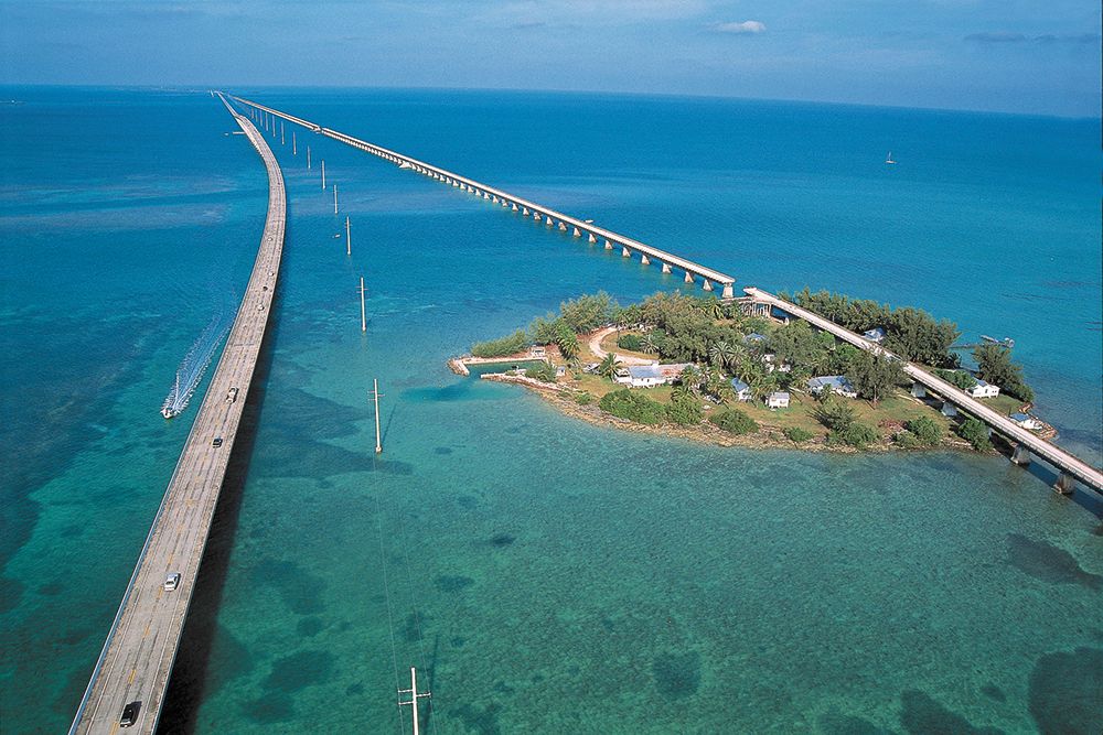
Pigeon Key
The Old Seven Mile Bridge
There is arguably no more important spot along the 120 mile Overseas Highway than Pigeon Key – Flagler’s construction headquarters and the start of the most spectacular (and beautiful) section of all along the overseas route – the famous Seven Mile Bridge. Between 1908-1912, as many as 400 workmen lived on the five acre Pigeon Key and this heritage is remarkably preserved as a special destination treat to all who traverse the 2.2 mile section of what locals now call the “Old Seven Mile Bridge”. The Seven Mile Bridge, in order to speed up construction, was divided into four parts.
The first three, Knights Key Bridge, Pigeon Key Bridge and Moser Channel bridge, consisted of steel-girder spans laid on top of concrete foundation piers. The piers were secured to bedrock which in some cases was 28 feet below the waterline. A 253 swinging span was inserted for passage of boats between the Atlantic and Gulf. The fourth section of the bridge was called the Pacet Channel Viaduct and it consisted of two hundred+ 53 foot concrete arches. Unfortunately, the Great Labor Day Hurricane of 1935 decimated much of Flagler’s Key West Extension. The railroad, already in receivership, chose not to rebuild, citing financial difficulties. It had by this time become cheaper to haul cargo by truck than by train. The county’s Overseas Road and Toll Commission purchased the right of way from the Florida East Coast Railroad and converted the single track railway trestles, which remained intact after the hurricane, into two-lane bridges for automobiles.
The highway from Homestead to Key West opened for traffic in 1938. Today the Old Seven Mile Bridge (the original Knights Key Bridge) to Pigeon Key is listed on the National Register of Historic Places and is home to the only authentic museum documenting construction of the Overseas Railroad. Since 1982, when a new Seven Mile Bridge section was completed to accommodate modern traffic and taller ships, the section known as Old Seven Mile Bridge has served as a world famous fishing pier, jogging, and walking route, and of course the major path to Pigeon Key. Due to structural problems, the Old Seven Mile Bridge closed for repairs in 2016 and will not reopen until 2021. The $77 million project to restore the bridge’s structural capacity includes repairs to concrete and steel, a new pedestrian railing, signs and pavement markings. In past years, tens of thousands of visitors enjoyed a ride on “Henry” — an authentic looking train designed to accentuate the visit to Pigeon Key. Since the repairs began, “Henry” has not been able to traverse the span so for now, you’ll need to visit via the island’s ferry service.